Autographic Visualization (IEEE VIS Paper)

Autographic Visualization (IEEE VIS Paper)

Autographic Visualization (IEEE VIS Paper)

Data by Proxy — Material Traces as Autographic Visualizations

Per definition, data visualization can only begin when data exists. As a result, the process of data collection remains mostly hidden. Visualization methods are designed to reveal patterns in data; however, many public controversies are not about what is “in” the data, but about the circumstances of data collection.

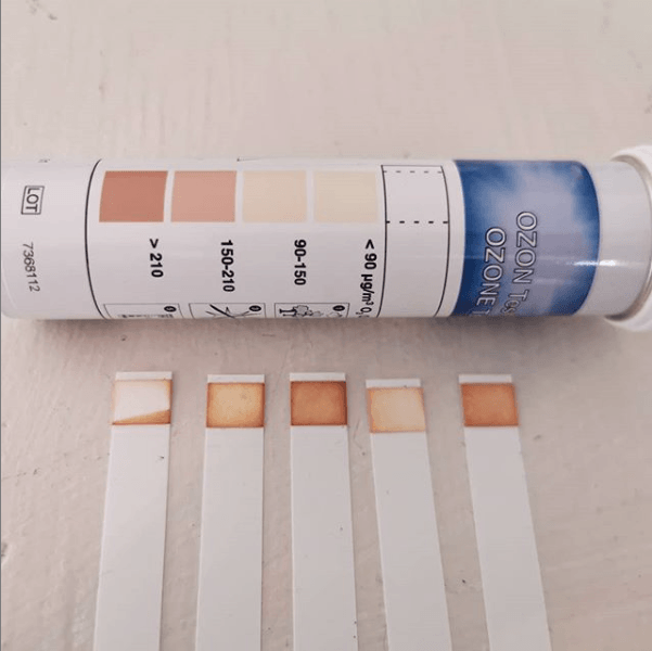
Autographic visualization is a speculative counter-model to data visualization based on the premise that data are something material rather than something abstract and symbolic. The design operations of autographic visualization aim to set the conditions that allow material phenomena to reveal themselves — as physical traces or environmental indicators. The design of autographic or self-registering devices has a long history that is closely connected to the history of data visualization. Today, autographic visualization can be used to make the process of data collection more legible and accountable. The comparison between the two models allows probing the epistemic assumptions behind information visualization and uncovers linkages with the rich history of scientific visualization and trace reading.

link to IEEE VIS paper
VISAP pictorial

Paper: Maps of Daesh

Paper: Maps of Daesh

Paper: Maps of Daesh

The Cartographic Warfare Surrounding Insurgent Statehood 

The ongoing Syrian civil war raises new cartographic challenges, including the ethical question of how the self-proclaimed Islamic State should be represented. States and news organizations face a conundrum: by mapping IS territory, they implicitly acknowledge its statehood. I investigate how different mapping methods carry different connotations for representing the strength and nature of the terror state, arguing that the statehood the IS is symbolically contested through cartographic choices that reflect the diverging interests of map makers.

Based on a comparative study, this article investigates the visual languages of IS sanctuary maps as published by news agencies, intelligence agencies, or circulated by the insurgents themselves. I argue that the statehood of territory held by the IS is symbolically contested through cartographic choices that reflect the diverging interests of the map makers. Beyond official representations, the article also considers the maps created by amateur conflict mappers and visual forensics experts, who extract and cross-reference information from social media including posted cell phone and drone footage, georeferenced tweets, and satellite images. I argue that the novel visual strategies developed by these practitioners for presenting visual evidence emphasize nonrepresentational aspects of cartography and represent a countermodel to established cartographic languages that follows an indexical rather than iconic or symbolic paradigm. 

Link    Pdf      Link to the Map Archive 

Pdf with original figures from the paper 

Tracings of original images by Azam Majooni


Paper: Manila Improstructure

Paper: Manila Improstructure

Paper: Manila Improstructure

An improvisational perspective on smart infrastructure governance

In this new paper, Katja Schechtner and myself look at appropriation in the power-grid of Manila. Inventions by residents, bricolage, and improvisational repair; tactics to combat power theft by electricity providers, and the efforts of local government to mediate the diverse interests and of the actors involved.

Based on ethnographic fieldwork in Manila and interviews with city officials, planners, residents and local activists, we develop the notion of  improstructure as a conceptual model for understanding infrastructure governance as an improvisational process of “call and response” in a network of diverse actors.

We apply this perspective to ongoing modernization efforts by the city of Manila and its utility companies, involving smart city technologies including sensor networks, drone mapping, and data analytics. We argue that despite the placeless and generic rhetoric surrounding these technologies, they constitute improvisational responses to local conditions. We conclude by formulating design principles for improvisational infrastructure governance, which are not limited to the Global South, but also apply in developed countries.

Published in Cities Journal

You can read the preprint here

Monograph “Waste is Information” (MIT Press)

Monograph “Waste is Information” (MIT Press)

Monograph “Waste is Information” (MIT Press)

Waste is Information – Infrastructure Legibility and Governance

By Dietmar Offenhuber, foreword by Carlo Ratti

Waste is material information. Landfills are detailed records of everyday consumption and behavior; much of what we know about the distant past we know from discarded objects unearthed by archaeologists and interpreted by historians. And yet the systems and infrastructures that process our waste often remain opaque. In this book, I examines waste from the perspective of information, considering emerging practices and technologies for making waste systems legible and how the resulting datasets and visualizations shape infrastructure governance. He does so by looking at three waste tracking and participatory sensing projects in Seattle, São Paulo, and Boston.

I expand the notion of urban legibility—the idea that the city can be read like a text—to introduce the concept of infrastructure legibility. He argues that infrastructure governance is enacted through representations of the infrastructural system, and that these representations stem from the different stakeholders’ interests, which drive their efforts to make the system legible. The Trash Track project in Seattle used sensor technology to map discarded items through the waste and recycling systems; the Forager project looked at the informal organization processes of waste pickers working for Brazilian recycling cooperatives; and mobile systems designed by the city of Boston allowed residents to report such infrastructure failures as potholes and garbage spills. Through these case studies, I outlines an emerging paradigm of infrastructure governance based on a complex negotiation among users, technology, and the city.

LA Noise Array

LA Noise Array

LA Noise Array

Offenhuber, Dietmar, Sam Auinger, Susanne Seitinger, and Remco Muijs. 2018. “Los Angeles Noise Array—Planning and Design Lessons from a Noise Sensing Network:” Environment and Planning B: Urban Analytics and City Science, August. [pdf]

The urban soundscape is the result of complex interactions between activity and the built environment. It is multifaceted, changes constantly across space and time. The auditory space has a distinct shape and spatial structure. The soundscape is invisible, yet it has a profound impact on how we make sense of our environment.

Ambient noise is an almost universally accepted concern for public health. Among the scientific community as well as the general public there is a broad consensus that noise can be both annoying and unhealthy. Epidemiological studies have shown that populations exposed to night-time aircrafts and road traffic noise tend to suffer from elevated blood pressure. Beyond these general effects, parts of the population, including children and the elderly are especially sensitive to environmental noise. Frequency also matters. Many people are more sensitive to low frequencies, which are emitted by ventilation systems, vehicles, and electric machinery. However, low frequencies are generally underestimated in conventional noise measurements, which are the basis of most noise ordnances.

To enable a differentiated understanding of urban auditory phenomena requires a large number of simultaneous measurements, extended over time. Until now, such fine-grained measurements of ambient noise were not available. Point measurements conducted by cities and agencies are too sparse to allow an investigation of how the built environment and human activity influence the soundscape, and which policies, urban design measures are effective in addressing noise pollution. Attempts to address the lack of data through crowd-sourced measurements conducted by citizens using their smartphones are hampered by unsystematic data collection and inaccurate measurements.

In this pilot project, a collaboration with Philips Lighting and the city of Los Angeles, we use urban streetlights for measuring the urban soundscape at a fine-grained level, allowing for an in-depth analysis of the urban soundscape and supply evidence for policy measures.

Link to the project: http://noisearray.org